


By Sara Beth Williams–
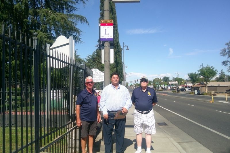
A ceremony was held Oct. 7 in front of the Sylvan Cemetery to unveil an historical placard recognizing Auburn Boulevard as part of the Lincoln Highway.
The city, in partnership with CHANT Neighborhood Area 3 board member Andrew Saunders and the Lincoln Highway Association California Chapter, identified four historical route points along Auburn Boulevard to be marked as points on the historic transcontinental Lincoln Highway.
Multiple city leaders, community members, City Council members, and Kelsey Nelson, the president of CHANT, attended the unveiling of the placard at Sylvan Cemetery, along with the president and vice president of the Lincoln Highway Association California Chapter.
Saunders said his vision for installing historical placards only became a reality because of the help of the city and General Services Director Regina Cave, who brought the idea to fruition.
“Visions and dreams don’t happen without a date put on it, and today’s that date,” Saunders said.
The rectangular placard design has a brown, red, white, and blue color scheme, with “HISTORIC” written on top across a brown banner, and a large L in the center of the words “LINCOLN HIGHWAY.”
“The chapter really appreciates the effort of Andy here,” president of the Lincoln Highway Association California Chapter Joel Windmiller said.
The landmarks with new placards have also been added to a national Lincoln Highway map, which is accessed through the Lincoln Highway Association’s website. The map lists every historical landmark along the transcontinental route and provides historical notes regarding each landmark.
Windmiller said each state chapter of the Lincoln Highway Association is in charge of marking and maintaining the historic transcontinental route. According to the Association, the national Lincoln Highway map is traveled by many Lincoln Highway enthusiasts.
“Citrus Heights is now on the map,” Saunders said.
Cave confirmed Wednesday that two more historical placards have also been installed along the old Lincoln Highway route, including one on Auburn Boulevard adjacent to the 14-Mile House near Donegal Drive and another on Auburn Boulevard close to the 12-Mile House near Devecchi Avenue, south of Greenback Lane.
The city also plans to install a fourth Lincoln Highway placard at the northern city limits when a gateway arch into the city is completed, Cave said.
The Lincoln Highway began in 1913 and lasted until the mid-1920s. Running from east to west, travelers could take Auburn Boulevard, turn at what is now Sylvan Corners, and travel across the country. The transcontinental route ran from San Francisco to New York City, with Lincoln Park in San Francisco as the western terminus.
Citrus Heights Historical Society president Larry Fritz told The Sentinel previously that there were once six different mile houses located in the vicinity of what is now Citrus Heights used as way stations where people traveling the two-day route between Sacramento and Auburn could spend the night.
“That’s how Citrus Heights got started,” Fritz said.
The first attempts to commemorate the Lincoln Highway route came in 1928, Fritz said, when the Boy Scouts of America built over 2,000 concrete markers at each mile along the route because “they knew it was going away.”
The Lincoln Highway transitioned into Highway 40 in the mid-1920s when the government dropped named highways and transitioned to a numbered highway system. To this day, a sign at the intersection of Antelope Road and Auburn Boulevard denotes both names, Fritz says.


