

By Sara Beth Williams–
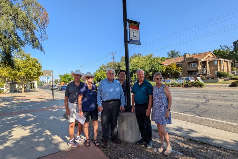
A host of city leaders, school personnel, alumni, and community members gathered together to celebrate the unveiling of an Historic Lincoln Highway Memorial Placard in front of San Juan High School in Citrus Heights.
The ceremony, which took place a day after school kicked off for the 2025-26 year, featured multiple speakers before the sign’s unveiling. An historian spoke of the humble beginnings of San Juan High, and the high school’s current principal David Levis spoke of the positive impact of both the Lincoln Highway and San Juan High School on the community over the last century.
“Just as the Lincoln Highway once connected communities across America, San Juan High School has been a place where generations have come together,” Levis said.
Andrew Saunders with the Lincoln Highway Association California Chapter spearheaded the event and also presented a quick lesson on the history of the Lincoln Highway and its impact on the region when it was only known as Sylvan. The route down Greenback Lane, where San Juan High School resides, became operational in 1928.
Other speakers included Citrus Heights Arts founder GiGi Rayford, Executive Director of the Citrus Heights Chamber of Commerce Sheri Merrick, and Albert Fox from the Rotary Club of Citrus Heights, who Saunders called “instrumental” in helping collaborate between different entities in order to get the project approved. The office of Assemblyman Josh Hoover also presented Levis with a certificate.
The Lincoln Highway, America’s first transcontinental roadway, once routed travelers through areas including Roseville, Citrus Heights, Orangevale, and Fair Oaks. Saunders said the new signage is intended to promote “travel and tourism for points of interest” along the route, encouraging visitors to stop at sites like the historic Rusch Home in Citrus Heights and others.
Saunders has been traveling and presenting to other jurisdictions and pushing for the installation of Historic Lincoln Highway placards in Fair Oaks, Orangevale, and Roseville to help commemorate and memorialize the historic route.
The rectangular placard design has a brown, red, white, and blue color scheme, with “HISTORIC” written at the top across a brown banner and a large L in the center of the words “LINCOLN HIGHWAY.”
The new sign hangs from a light pole directly in front of the high school. Saunders’ goal is to bring awareness not only to the Lincoln Highway but also to Citrus Heights and to get the CA tourism board to “recognize our area as a historically significant landmark,” Saunders said in an interview.
The placard’s development was made possible through partnerships between the Lincoln Highway Association California Chapter, the San Juan Unified School District facilities team, and the City of Citrus Heights General Services Department, among others.
Previously, Saunders, in partnership with the city, CHANT Neighborhood Area 3, and the Lincoln Highway Association California Chapter, identified four historical route points along Auburn Boulevard, which was the original Lincoln Highway route.
The landmarks with new placards have also been added to a national Lincoln Highway map, which is accessed through the Lincoln Highway Association’s website. The map lists every historical landmark along the transcontinental route and provides historical notes regarding each landmark.
The city also plans to install an Historic Lincoln Highway placard at the northern city limits where a gateway arch leading into Citrus Heights will be completed, according to General Services Director Regina Cave.
The Lincoln Highway transitioned into Highway 40 in the mid-1920s when the government dropped named highways and transitioned to a numbered highway system. To this day, a large sign at the intersection of Antelope Road and Auburn Boulevard denotes the names of both highways.


