


By Nadezhda Chayka Otterstad–
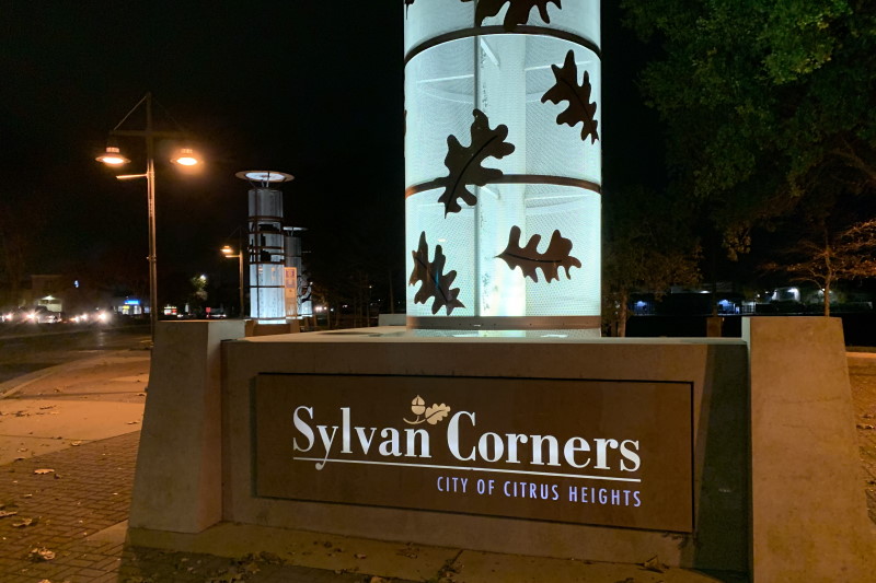
Seven prominent towers stand at Sylvan Corners in Citrus Heights, but the meaning behind them is largely unknown to the thousands of drivers who pass through the busy intersection each day.
To learn about the meaning behind the distinctive towers, The Sentinel contacted Teena Stern, who serves as the city’s volunteer archivist. She provided a copy of a September 2004 edition of the city’s Connections newsletter, where the meaning behind each tower was described.
The towers first appeared a little over 15 years ago, as part of the first phase of the Auburn Boulevard Complete Streets Project, which saw the renovation of the Sylvan Corners intersection, where Sylvan Road, Old Auburn Road and Auburn Boulevard meet.
The main tower stands 32 feet tall, while the other six towers are 22 feet in height. Each has accent lighting which appear at night, along with a plaque explaining the history.
Below is a summary of the newsletter’s description of each tower:
Sylvan Corners Tower. This prominent column, marked by oak leaves, hails back more than 150 years ago, when W.A. Thomas gave five acres of land for a first school in what was then known as Center Township. He named the school Sylvan for the many trees on the land, with the term coming from the Latin word “sylva,” which means “forest” or “wood.” Soon, the entire area was named Sylvan.
 Highway 40 Tower. This 22-foot pylon, marked with a Highway 40 symbol, hails back to the early 1900s when farmers traveled on dust-covered roads in the area. By 1913, the first transcontinental road, Lincoln Highway, was established, enabling travel from New York City all the way to San Francisco.
In 1926, the roadway was designated as Highway 40, and in 1964, the highway was decommissioned when Interstate 80 entered the scene as a federal highway system.
Transportation Tower. The three wheel-shaped circles on this column tell the story of transportation on Auburn Boulevard progressing from wagon wheels around 1847 to trains in 1864 to the first stage line in 1914.
With the introduction of the Central Pacific Railroad in 1964, Roseville became an important market center which led to Sylvan Corners becoming the central route for farmers to take their goods to market and for people to shop. Fifty years later, the Golden Eagle Barker Line became the first stage line in the area.
 Rancho del San Juan Land Grant Tower. Marked with blue flowing lines, this pylon hails back to 1844, when the area from the American River all the way to Sylvan was part of a 19,982-acre land grant from Mexico. By 1851, Center Township was established, with a few ranchers raising cattle and farming grains in the area. It was renamed Sylvan District in 1860.
Around fifty years later, a real estate developer subdivided Sylvan District into 10-acre parcels and renamed the area “Citrus Heights” in hopes of catching the eye of investors from the eastern parts of United States.
Railroad Tower. Three brown lines on this tower symbolize the ground-breaking for Central Pacific’s portion of the first transcontinental railroad. A year later, the railroad passed through the area heading into Promontory Point, Utah.
With the new railroad system in place, more settlers flocked to the area and farmers found that transporting their farm goods became easier and cheaper, which resulted in more extensive farming. Popular inns alongside Auburn Boulevard were subsequently converted into private residences, as need for travel on horse drawn carriages became extinct.
One former inn, the 14-Mile House, still stands on Auburn Boulevard. The 2,100-square-foot home sold most recently last year, after being listed for $499,900.
Related: The historic ’14-Mile House’ in Citrus Heights has found a buyer
Farming Tower. The wheat emblazoned on this column tells of the area’s farming industry being the primary livelihood in the area. One of the area’s first settlers, Joseph Gray, began ranching in 1853 along Auburn Boulevard and resided in the 14-Mile House. Gray was the first farmer to grow grapes and grain in Sacramento County.
Notably, farmers had to work long and arduous days of clearing their land of oak trees before they could begin any planting. Crops such as wheat were sold to Sacramento flour mills.
School/Library Tower. The art on this pylon appears to indicate books on a shelf, hailing back to 1862 when Sylvan School became one of the first schools in the area. The one-room schoolhouse was then sitting at the northwest corner of Sylvan Road and Auburn Boulevard, but was subsequently moved to where it now sits on Sylvan Road and serves as a veterans community center.
The original schoolhouse had one classroom and served 40 students. In 1921, Sylvan School was home to a local branch of the Sacramento County Library, which moved several times and then finally was established at its current location at Auburn Boulevard and Van Maren Lane. San Juan High School later opened in 1913 on the second floor of the San Juan Grammar School. Two years later, a newly built San Juan High School opened its doors on Greenback Lane.
Editor’s Note: The city also has installed other landmarks to highlight the area’s history, including a half-dozen plaques outside historical points of interest and the “Lincoln 40” bench lettering at the intersection of Auburn Boulevard and Antelope Road. Read more: The history behind those ‘Lincoln 40’ signs in Citrus Heights

